The rivers of the Bryansk region depend on precipitation and snow melting often no less than on groundwater. For this reason, the value of the water balance fluctuates from year to year. Almost all rivers in the region belong to the Dnieper basin, and the main waterway, the Desna, is its tributary. The river network is dense and relatively evenly distributed over the region, so there are no arid and barren areas here. At the same time, there are only a few long rivers approaching the 100-kilometer mark, the rest are much shorter.
Of particular interest to travelers is Nerussa, as it flows through the natural biosphere reserve "Bryansk Les". Voronus is also connected with it: on its banks there are rare species of birds and places for stopping migratory waterfowl.
The longest rivers in the Bryansk region
List of the largest rivers flowing through the region.
Gum
The main waterway of the region, a tributary of the Dnieper. In addition to the Bryansk region, it also flows in the Smolensk region and through the territory of Ukraine. Moving south, the channel becomes wider and wider. Floodplains are grasslands, and meadows, forests and swamps are found throughout the Desna. A Paleolithic site was found on the right bank near Bryansk. There are many tributaries, including Owls, Bolva, Navlyu.
The length of the river is 1130 km, in the Bryansk region - 413 km.

Iput
It flows in the Bryansk and Smolensk regions, as well as in Belarus. The Krutoyarsk inter-collective farm hydroelectric power plant was built on the river. The upper course is a swampy floodplain, the middle course is a plain with a predominantly sandy coast. The channel is weakly branched, some sections are ideal for rafting. It is navigable from the village of Krutoyar to the city of Surazh.
The length of the river is 437 km, in the Bryansk region - 290 km.

Conversation
The left tributary of the Sozh River, related to the Bryansk and Smolensk regions, as well as to two regions of Belarus. The banks are steep and sandy, and there are frequent sloughs. The rifts are rich in aquatic vegetation. The floodplain is characterized by swamps and small lakes. Pine and oak forests are found all along the coast. The tributaries are small, but they form a dense network.
The length of the river is 261 km, in the Bryansk region - 54 km.

Dreams
It originates in the Bryansk region, runs along the state border and flows into the Desna on the left side of the territory of Ukraine. Water from the Snov River is used for irrigation of agricultural land. Meals are mainly provided by melt water. It is navigable in the lower reaches, where the channel width reaches 40 meters. Some areas are fishy, crucian carp, ide, pike, roach are found.
The length of the river is 253 km, in the Bryansk region - 125 km.

Bolva
The left tributary of the Desna, also related to the Kaluga region. The section of the channel between Bryansk and the village of Tsementny plays an important role in the logistics of the region and is used for transporting goods. The spring flood forces the residents of the village of Raditsa-Krylovka to use boats for movement. The banks are steep, often overgrown, and sandy beaches are found mainly on bends.
The length of the river is 213 km, in the Bryansk region - 92 km.

Judgment
It originates near the village of Bobylevo, flows almost completely through the Bryansk region, but flows into the Desna after crossing the border with Ukraine. The tributaries are characterized by a faster current than the Sudost itself. The village of Sluchevsk has several archaeological sites. In the area of the river, signs of a deterioration in the ecological situation were repeatedly observed, including the mass death of fish.
The total length of the river is 208 km.

Raditsa
The left tributary of the Bolva, flowing within the Bryansk region. The mouth is the village of Raditsa-Krylovka. In the spring, the river overflows heavily, flooding the surrounding area. There are two dam-type lakes on the riverbed. The manufacturer Maltsov had a hand in the creation of Lake Raditskoye. In the past, the waters of Raditsa were actively used in production: on its banks, at various times, an iron and glass works, as well as a mill functioned.
The length of the river is 198 km.

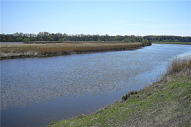
Nerussa
It originates on the territory of the Oryol region, but the main part of the channel is located in the Bryansk region. The river in some areas was deliberately straightened for the needs of land reclamation. The reservoir has a good reputation among kayakers. There are few inflows, there are only two left: Lentcha and Lokna. In 1987, the shores of Nerussa became part of the Bryansk Forest Natural Biosphere Reserve.
The total length of the river is 161 km.

Navlya
The source is located near the village of the same name in the Oryol region. Several small bridges were built on the river, including a suspension one near the village of the same name in the Bryansk region. After reclamation work in the 70s of the last century, the river became shallow. The food is snow, ground and due to precipitation. There are fish places, but large representatives of ichthyofauna cannot be caught here.
The total length of the river is 126 km.

Resset
Belongs to the Bryansk and Kaluga regions, a significant part of the channel runs along the border of these regions. The etymology of the name refers to the words "swamp", "fork", "liquid". One of the important tributaries of the Zhizdra River. The Bolon tract is the source of the Resseta. The area is notorious for the events of the Great Patriotic War. The 50th Army of the Bryansk Front lost almost its entire composition on the river bank.
The total length of the river is 123 km.

Vetma
The source is in the Kaluga region, but most of the river belongs to the Bryansk region. In the upper course, the channel runs across plains and fields. In the lower and middle - in wooded areas. In the century before last, timber was rafted along Vet'ma. Now the reservoir has no economic purpose, but it attracts kayakers. During floods, it spills heavily.
The total length of the river is 112 km.

Unecha
It flows entirely within the Bryansk region. There is a city of the same name on the river, which serves as an important transport hub. Unecha originates in a small swamp, overgrown with forest, near the village of Rassukha. The lower course is considered to be more polluted due to industrial and domestic wastewater. The tributaries are predominantly insignificant and are classified as streams.
The length of the river is 92 km.

North
It flows into Nerussa, almost the entire channel passes through the Bryansk region, but the Kursk river is also related. It originates from the confluence of two streams near the pond. In the summer, kayaking along the Seva River, and the sandy beaches are filled with locals. In winter, the reservoir is covered with a thick layer of ice. Fish is found in abundance, so there are many people who like to sit on the shore with a fishing rod during the season.
The total length of the river is 88 km.

Sheaf
An alternative name is Snot. It originates in Kaluga, and flows into the Desna on the territory of the Bryansk overgrown near the village of the same name. There is a large pond in the middle course, the flow is regulated. A dozen and a half settlements are founded on the shores, but they are all medium-sized. The pool is predominantly wooded. Sheaf is a spawning ground for sturgeon and salmon fish.
The total length of the river is 86 km.

Jealous
The stress in the name can be put on both the first and the second syllables. The left tributary of the Desna belongs to three districts of the Bryansk region: Karachevsky, Vygonichsky and Navlinsky. The largest settlement on the coast is the village of Sinezyorki. There are only two relatively large tributaries. In the village of Revny, a manor park has been preserved, the history of which is associated with the name of Konstantin Paustovsky.
The length of the river is 76 km.

To snow
The name of the reservoir is derived from the snow-white sandy shores. It is a left tributary of the Desna. The source and mouth are located within the Bryansk region. On the banks of Snezheti there are several settlements, including Karachev, and the Beloberezhskaya Pustyn monastery. Lampreys are found in the vicinity of Partizanskaya Polyana, and catfish are found in the lower reaches. The rest of the ichthyofauna is typical for the region.
The length of the river is 80 km.

Voronitsa
Belongs to the lands of the Smolensk and Bryansk regions. It flows along the border between them.Not far from the mouth there is an archeological monument called "Forty-three kurgans". Other ancient burials were also found on the right bank. Voronitsa is characterized by a small number of tributaries and a very winding channel. It is known more than other small rivers in the region, as it is mentioned in the "Tale of Bygone Years".
The total length of the river is 74 km.

Gabia
The river of the Smolensk and Bryansk regions. The source is a forest swamp near the Glass Guta, and flows into the Desna near the village of Troitskoye. Five bridges have been thrown across the channel. Near the village of Mezhnik, which is part of the Gabia basin, there is the highest point in the region - 292 meters above sea level. Of the fish, perch, roach and pike are especially common. Wild otters and beavers can be found along the coast.
The total length of the river is 74 km.

Vablya (tributary of Judgment)
River in the central part of the region. It originates in the Starodubsky district, flows into the Sudost in Pogarsky. For the most part, it is shallow, it allows it to freeze quickly in winter and also quickly free itself from ice. The Vabli waters are subject to pollution from the Starodubskiy Vodokanal. Archaeological monuments - fortified settlements and settlements of the V-XIII centuries - are met along the banks.
The length of the river is 61 km.

Voronus
It flows within the boundaries of the Mglinsky district of the Bryansk region. Near the Klinok farm, on the left bank, there are burial mounds dating from the 9th-12th centuries. Vronus runs along the southern border of the Kletnyansky nature reserve, which is part of the Bryansk Forest Nature Biosphere Reserve. Here you can find rare representatives of the avifauna, for example, the great bode or the black stork. In the lower reaches there are traditional sites for migratory waterfowl.
The length of the river is 60 km.